Sardinien entdecken
Von der Costa Smeralda bis in die Barbagia.
Die großen Landschaften Sardiniens.
Northern Sardinia is significantly defined by the Metropolitan City of Sassari, which stands as the region's urban center with approximately 120,497 inhabitants. As the island's second-largest city, Sassari serves as an administrative and cultural hub. The surrounding area includes various characteristic municipalities, including well-known coastal spots such as Porto Torres and Stintino in the northwest, as well as Alghero. The region spans a vast area reaching from the borders of Olmedo to the heights of Osilo and Sennori, blending urban life with the adjacent rural and coastal districts of the province.
Eastern Sardinia is significantly shaped by the historical and geographical region of Ogliastra. This area encompasses both the province of the same name and a distinctive landscape in the central-eastern part of the island. The region also includes an archipelago, with the main island of Ogliastra located off the coast. The area is known for its pristine nature and the characteristic combination of mountain ranges and coastal sections. As one of the most authentic zones of the island, it provides insights into traditional Sardinian geography and administrative structures. Ogliastra is regarded as an important cultural and scenic heritage that decisively influences the identity of the eastern half of the island.
Southern Sardinia is significantly defined by the island's capital, Cagliari, which serves as the economic and cultural hub located on the gulf of the same name. Featuring a major port, a long-standing university, and theological faculties, the city forms the core of an extensive agglomeration. As an archbishopric seat, the region combines historical weight with modern administrative importance. Its geographic position on the southern shore gives it a central role in maritime trade, making it the most vital urban center of the autonomous region, with the city itself home to over 146,000 residents.
Western Sardinia is significantly shaped by the provincial capital Oristano. Located in the central-western part of the island, this city has around 30,007 inhabitants and serves as an important cultural and administrative hub for the region. The surrounding area is characterized by its coastal location, providing insights into authentic Sardinian life away from the major tourist centers. Oristano acts as an ideal starting point for exploring the western side of the island, which is known for its history and local community. The region blends urban structures with the natural landscape of the western coastline, offering visitors a calm and factual atmosphere for exploration.
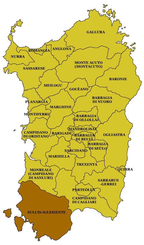
Central Sardinia is defined by the Barbagia, a multifaceted rocky plateau located south of Nuoro in the eastern part of the island. Divided from north to south into several distinct areas—including Barbagia Ollolai, Mandrolisai, Belvi, and Seulo—the region offers a diverse geographic landscape. This upland area is known for its rugged rock formations and its significant expanse across the island's interior. As a geographical core, it provides a unique look at the highland structures that stretch across this part of Sardinia, showcasing a side of the island characterized by its elevated terrain.
Barbagia is a prominent rocky plateau located in eastern Sardinia, south of the city of Nuoro. This multifaceted region is geographically divided into several distinct areas, including Barbagia Ollolai, Mandrolisai, Belvi, and Seulo. Known for its rugged landscape, it represents one of the most traditional and geologically significant areas of the island. The north-to-south division into these four specific districts highlights the topographical diversity of the Sardinian highlands, making it a central geographic feature of the island's interior.
The coastal stretch of Costa Paradiso is located in northern Sardinia and is part of the municipality of Trinità d'Agultu e Vignola. Situated in the province of Gallura, the administrative area has around 2,600 inhabitants. The region has a long administrative history, with the area historically known as Vignolas. This name was used in official documents of the Kingdom of Sardinia until the 18th century. Today, the location is a prominent point on the island's northeastern coast, blending modern settlement structures with the traditional Gallurese landscape.
Costa Rei is a maritime district belonging to the municipality of Muravera in southeastern Sardinia. This coastal settlement serves as a significant destination for visitors exploring the island's shoreline. As a formal fraction of Muravera, it plays a key role in the administrative and geographical structure of the region. Its seaside location defines the character of the area, making it a central point for maritime tourism. Closely connected to its parent municipality, the district provides a gateway to the eastern coast of Sardinia for travelers seeking local coastal experiences.
Marmilla is a geographical subregion located in south-central Sardinia. The area is defined by distinct natural borders: the Giara di Gesturi and Giara di Serri plateaus to the north, and Monte Arci to the northwest. To the south and west, it borders the Campidano plain, while the Flumini Mannu river marks its eastern boundary. Situated between volcanic massifs and low-lying plains, Marmilla serves as a central geographical link within the island's diverse landscape.
Ogliastra refers to a versatile region on the eastern coast of Sardinia. The term encompasses both a historical landscape and an Italian province of the same name. The region also includes the offshore island of Ogliastra. The area is characterized by its geographical position between the Tyrrhenian Sea and the inland. As an administrative unit, the Province of Ogliastra serves the management of this traditional stretch of land, while the landscape itself is known for its natural significance. The combination of coastal sections and the interior makes this part of the island a central component of Sardinian geography.
Located on the central-western coast of Sardinia, the Sinis Peninsula stretches between the Bay of Is Arenas to the north and the Gulf of Oristano to the south. The surrounding waters to the west feature the Island of Mal di Ventre and the rock formation known as Scoglio del Catalano. This geographic area is a prominent feature of the Sardinian coastline, offering a distinct landscape shaped by its maritime position. The peninsula serves as a natural boundary, defining the coastal structure of the region and providing a unique geographical link between the northern bays and the southern gulf waters.
Sulcis-Iglesiente is a historical region located in southwestern Sardinia. As its name implies, it encompasses the territories of Sulcis and Iglesiente. Historically, this area was an integral part of the Judicate of Cagliari, specifically organized under the curatorates of Cixerri, Sulcis, and Nora. Today, the region stands as a significant cultural and geographical entity in the southwest of the island, reflecting a legacy that dates back to the medieval administrative structures of the Sardinian judicates, which continue to define its regional identity.